About
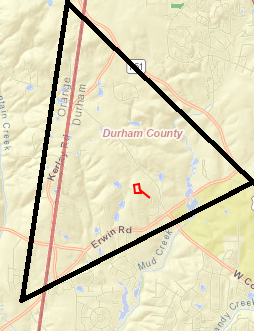
The Arrowhead community in Durham, North Carolina, is a rural area that includes agricultural and wooded areas. The locale has deep agricultural and environmental ties that contribute to Durham’s broad and diverse identity.
The Arrowhead name originates from its geographic shape on
the map. The community is roughly outlined by NC-751, Kerley
Road, and Erwin Road. The area is surrounded on two sides by
Duke Forest and on the other side by the Orange County Rural
Buffer.
.
-
Arrowhead terrain is unique and appreciated for several
reasons:
- Part of the New Hope Creek Watershed, containing
keystone riparians and additional riparians
- Water travels from New Hope Creek to Jordan Lake, to Haw River, to Cape Fear River Basin to the Atlantic
- The last hill region of the Piedmont
- Part of the Triassic Basin
- All of Arrowhead and surrounding rural land is included in the New Hope Corridor Open Space Plan
- Part of the Durham County Rural Buffer, alongside the Orange County Rural buffer that was established in the 80’s and preserved by successive generations

Actions
- Sign
the Petition via Email.
- Volunteer
in the effort.
- Keep aware via announcement list.
- Donate to the effort.
- The area is part of the New Hope Creek watershed. There
are streams that have a designated protection status to
prevent pollution of the New Hope.
- A substantial portion of the area has some of the few
family farms still left in the southern two-thirds’ of
Durham County.
- In 2004-05, Arrowhead community residents requested to
be placed in the Rural Tier. The Durham City Council and
the Durham County Board of Commissioners recognized the
importance of having a rural area that all residents can
enjoy
