CARE for Durham - Details on the Change
Durham Comprehensive Plan
The comprehensive plan outlines a set of goals and policies to direct land use and growth for Durham. Several of the policies seek to outline the growth within existing footprint, protect more ecologically important land and sensitive natural areas, and direct the engagement of the community in land use planning. Several policies clearly outline the considerations for UGB (Urban Growth Boundary) expansion including Policy 166, Policy 116 and Policy 118
Policy 166
Proposed changes to expand the Urban Growth Boundary (UGB) should only
be made when the proponent can demonstrate all three of the following:
1. The change does not expand the UGB further into a Critical Watershed.
2. The change does not significantly increase long-term infrastructure
maintenance costs for the City or County; and
3. The change would address a clear need for the community based on the
adopted Comprehensive Plan policies.
Reference: : https://www.durhamnc.gov/DocumentCenter/View/48893/Attachment-1-Draft-Comprehensive-Plan page 173
The proposed change does not meet any of these criteria.
1. It expands the UGB into a Critical Watershed
2. There is significant long-term infrastructure costs (per Planning staff
communication)
3. No resident has expressed a clear need to be in the UGB.
Policy 116
Establish an Urban Growth Boundary to discourage development on the edge of the city that strains existing infrastructure or prompts significant public investment in new infrastructure. Public sewer and water should not be extended past the Urban Growth Boundary, with limited exceptions to protect public health and safety.
Policy 118
Protect the rural character of Durham outside the Urban Growth Boundary.
Conflict with Other Policies
The change conflicts with other policies in the Comprehensive Plan, including Policies 76, 77, 79, 81, 82, 95, 96, 100, 113, 116, 118, 119, and 124. Some of these are:
Policy 79: Locate open space in new development so that it protects the most environmentally sensitive portions of the site and creates large and contiguous habitat areas, rather than narrow and disconnected strips of open space
Policy 95: Protect and regenerate the natural environment and biodiversity in Durham by incentivizing development that prioritizes reuse, infill, and low impact buildings and facilities.
Policy 124: Focus infill development in areas already served by public
water and sewer with unused capacity
Change is Not Need
• The Planning staff has stated that the current draft UGB has the capacity for 150,.000 additional new units over the next 30 years. Only 60,000 units will be required by Durham's growth.
Balance in Growth
• The City of Durham’s comprehensive plan for growth includes a balance of 70% urban and 30% rural designations. On this basis, the City recognizes that rural areas offer important value to Durham and the region overall. Until the recent requested change, Durham validated the rural designation for Arrowhead in its existing plan and in the draft plan
Effect on Others
• Arrowhead is surrounded by Duke Forest and the Orange Country Rural Buffer. It is part of a Critical Watershed
Duke Forest
Arrowhead is adjacent to the Duke University Research Forest which has not only sensitive natural areas and active teaching & research, but also nearly 100-years of scientific data that cannot be replicated elsewhere -- in less than a century. Duke University's recent Climate Commitment statement (https://climate.duke.edu/) makes the university-wide priorities clear.Thus far, the Forest has also served the community by allowing public
access to the benefit of Durham residents’ physical and mental health.
The nearby Shepherd Nature Trail & signage also introduces area youth
to science and the natural world.
However, pressures brought by increased density threatens to degrade the
Forest’s benefit to the nearby residents, the wider Durham community,
and beyond.

The Plan's Policy 81: Existing habitat areas and wildlife movement corridors should be left largely undisturbed to remain in their natural, vegetated state and to avoid fragmentation and disruption. These areas include Wildlife Habitat Areas or Natural Corridors in adopted open space plans or identified NC Natural Heritage Areas. Some disturbance may be allowed for road crossings, utilities, and stormwater infrastructure, if minimized. Staff will recommend against proposed structures or parking in these areas
Critical Areas Protection Plan for New Hope Creek
The New Hope CAPP https://www.durhamnc.gov/DocumentCenter/View/39698/CAPP_March2021?bidId= shows the portions of Arrowhead that are critical to protect.
The Riparian Area Management Plan https://www.durhamnc.gov/DocumentCenter/View/39699/RAMP_May2021?bidId= shows the plans protect the keystone and other riparian buffers.

Video on New Hope Creek Watershed
Eno-New Hope Connectivity Conservation Strategic Action Plan can be found here.
A stormwater analysis of a 2006 development in Arrowhead that was abandoned can be viewed here.
North Carolina Biodiversity, Wildlife Habitat, and Water Sucscptibility
The North Carolina Natural Heritage Program database indicates that there are records for rare species, important natural communities, natural areas, and/or conservation/managed areas within the proposed project boundary. See the report for details.
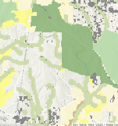
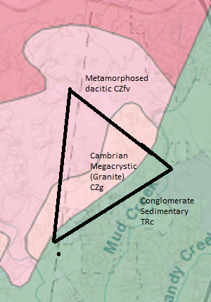
Here are two segments of maps from https://www.ncnhp.org/
The first map shows the areas in light green that are ranked 7 (on a 1-10 scale) for Biodiversity and Wildlife Habitat Assement. The dark green areas are Duke Forest, which ranks 9-10 on that scale.
The second map shows Ground Water and Surface Water Susceptibility. Red means Higher (of three values - Higher, Moderate, Lower).


Geology
A large part of Arrowhead is Cambrian Metamorphic (Granite). A proposed high school in the area was abandoned due to the expense of creating infrastructure in granite.

Orange County Rural Buffer
https://www.chapelhillrecorder.com/ruralbuffer/ gives a map of the rural buffer for Orange County which is next to Arrowhead
Definitions and Descriptions
Urban Growth Area
Durham’s new Comprehensive Plan proposes not to retain the Tier system but establishes one boundary, an Urban Growth Boundary, instead. This is an area beyond which annexations and utility extensions should not occur, limiting significant development. The proposed Urban Growth Boundary is smaller than the previously approved Suburban Tier. The Urban Growth Boundary balances the desires and needs to protect rural character, drinking water, and environmental lands, and the desires and needs to accommodate existing residents and to provide enough housing for population growth
Durham’s UGB or Urban Growth Boundary is defined as ”a proposed boundary included as part of the new Comprehensive Plan that indicates what parts of the County could have water and sewer (and other City services like trash collection) extended to them. As new water and sewer lines are built out, higher density development follows close behind.”
The proposed change for Arrowhead increases the Urban Growth Boundary.
Reference: https://www.durhamnc.gov/DocumentCenter/View/48893/Attachment-1-Draft-Comprehensive-Plan page 110
Rural and Agricultural (current place type)
Excerpt from definition of Rural and Agricultural place type: Rural and Agricultural Reserves maintain their rural character and contribute to Durham’s ability to provide local food access. Residents access recreational, commercial, and institutional places like parks,stores, and schools primarily by car or on-demand transit service. Intentionally placed sidewalks, bike paths, and crosswalks connect residents to and from nearby destinations like schools and small shopping areas. Limited development, including buildings and pavement, helps to preserve Durham’s drinking water resources, habitat for wildlife, and resiliency of the natural environment.
Mixed Use Neighborhood (What is in the proposed change)
Mixed Use Neighborhoods are built on large, previously undeveloped, or forested land on the outskirts of the city but within the UGB, or on large vacant sites within developed areas. These neighborhoods include centrally located civic, institutional, and commercial uses like shops, pharmacies, restaurants, offices, schools, and libraries that can be easily accessed by residents living in the surrounding homes. Non- residential uses should be located within a 15-minute walking distance of all residential uses.. Transportation infrastructure should support and encourage safe walking, biking, rolling, and riding transit. The mix of housing types envisioned in Mixed Use Neighborhoods should be at a high density, with a variety of heights, and price ranges to serve a diversity of needs. Green space and recreation should be integrated throughout the residential and non-residential parts of the neighborhoods in the form of playgrounds, parks, trees, and forested areas.
Characteristics Housing and Land Uses
• Dense, walkable neighborhoods with centrally located neighborhood businesses
• Development should provide a sensitive transition to nearby neighborhoods through building placement, design, massing, and step-down height
• Buildings set close to the street with porches, stoops, and short block lengths
• Ground floors of buildings should create street level activity, a large amount of windows, tall floor to ceiling heights, and architectural detailing
• Mix of residential, commercial, institutional, and civic spaces
• Housing mix includes apartments, condominiums, townhouses, senior residences, single-family homes, duplexes, accessory dwelling units, and tiny homes
Mobility
• Sidewalk and bike connectivity within and outside of the neighborhoods
• Direct routes for bicyclists and pedestrians to access transit stops located on major roadways
• Good street connectivity with multiple access points. Ideally a grid pattern would be planned for maximum connectivity and access.
• Street parking, structured parking, and drop off zones
Green Space
• If on a site with sensitive environmental resources: preserve these spaces as open space and cluster development on the least sensitive portions of the site
• Provide street trees, landscaped parking lots, plentiful tree preservation and replacements, generous stream buffers, and minimal grading.
• Publicly accessible recreational space should be provided with safe and easy access to surrounding neighborhoods.
Service Provision
• Development of new Mixed-Use Neighborhoods should be supported by existing public infrastructure like water, sewer, transit service, and roads, or phased to coincide with capital improvements
Reference: https://www.durhamnc.gov/DocumentCenter/View/48893/Attachment-1-Draft-Comprehensive-Plan page 189
